San Francisquito Creek Joint Powers Authority 7:1 Sloped Levee May Reduce 6 Acres of Parkland in East Palo Alto
A proposed 7:1 ratio levee may reduce up to 6 acres of future public park area in East Palo Alto.
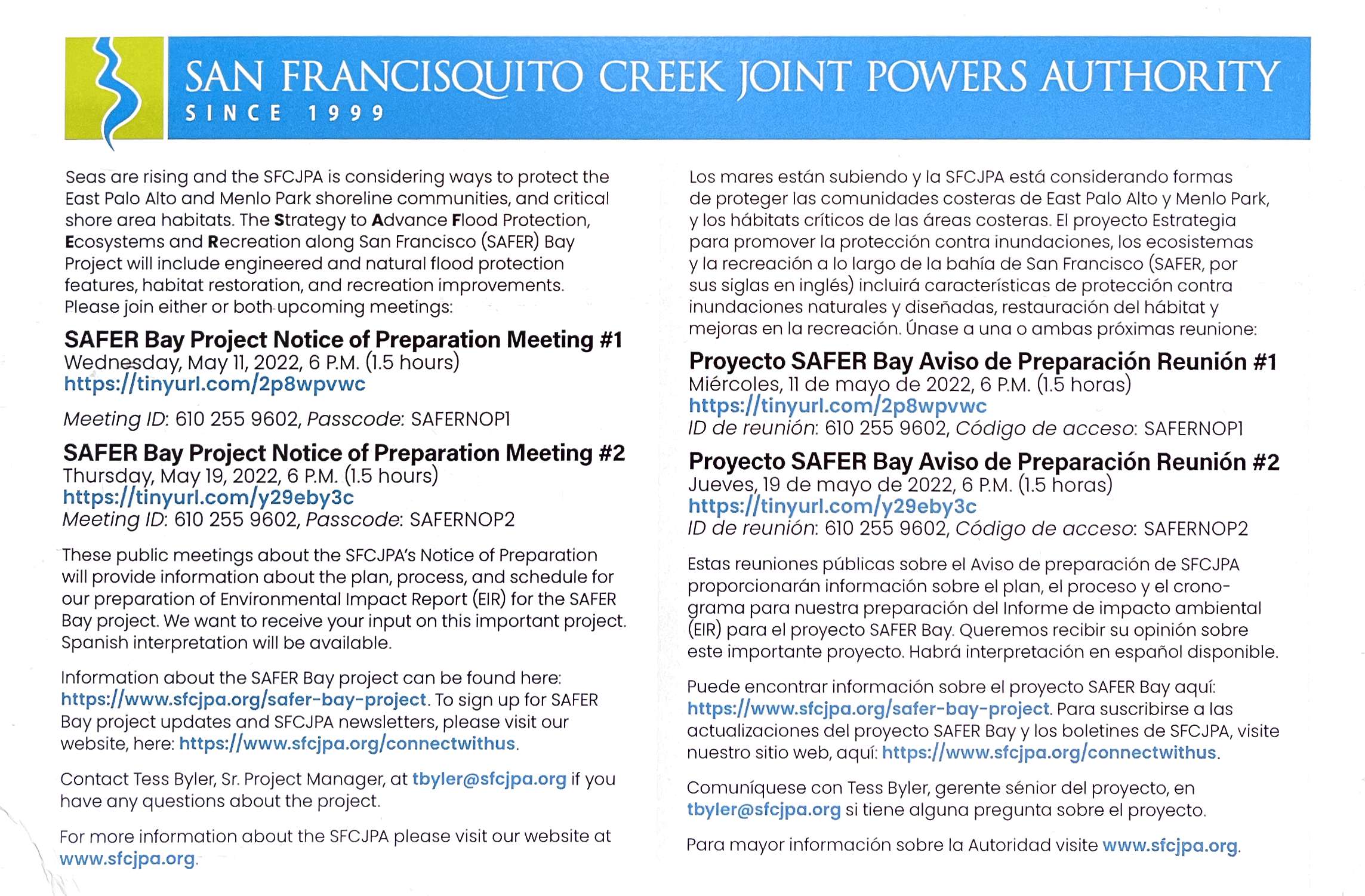
On April 22, 2022, the San Francisco Creek Joint Powers Authority published their Notice of Preparation (NOP) for the levees in East Palo Alto and Menlo Park. Here is PDF below in case the file location changes on their website after the publishing of this article.
The SFCJPA has good intentions in designing a new levee that will protect homes on the bayfront east side of East Palo Alto from being flooded during storms. While existing levees in the area have a 2:1 or 3:1 slope ratio, now the SFCJPA is proposing a much gentler 7:1 slope ratio because of these benefits listed on page 6 of the NOP:
The Project includes the creation of broad, gently sloped tidal marsh-upland transition zones (also referred to as horizontal levees), the ecological benefits of which include:
-Provision of high-tide refugia for the endangered salt marsh harvest mouse and California Ridgway’s rail, considered essential for the survival and recovery of these species;
-Provision of essential habitat for endangered marsh plants (e.g., salt marsh bird’s beak and California sea blight) and promotion of high plant and animal community diversity;
-Increased habitat diversity and biodiversity; and
-Accommodation of landward movement of tidal marsh with sea level rise.
Not mentioned in the text above is the logic that a gentler sloped levee will make it easier for animals to transition to higher land when the tide rises. Athletes "run or walk up steep slopes ranging between 10 degrees and 30 degrees" (Source). A 30 degree slope is a 3:1 ratio. A 10 degree slope is a 9:1 ratio. Imagine if you were an animal on the marsh while the tide was rising. Wouldn't it be easier to walk up a more gradual slope? That's the idea behind having a 7:1 slope.
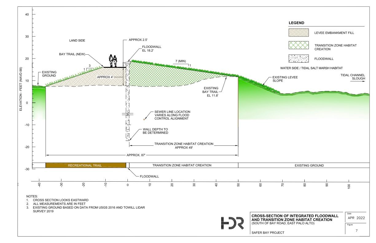
Unfortunately, building such a gently sloped levee is inefficient in its use of land, and would result in land being taken away. Building a levee 18.2 feet high and then having a 7:1 slope ratio implies a total width on the bay side of 18.2 * 7 = 127.4 feet. In this drawing, the entire slope isn't 7:1 so it's actually around 50 feet in total that the new levee would be taking away. Either the San Francisquito Creek Joint Powers Authority would take away land from the protected marshland to build the slope, or they would take away land from private owners, specifically around 50 feet of land along the length of the levee.
In Google Earth Pro, I've marked what 50 feet of lost land looks like on one segment of the San Francisco Bay Trail, in the yellow polygon.
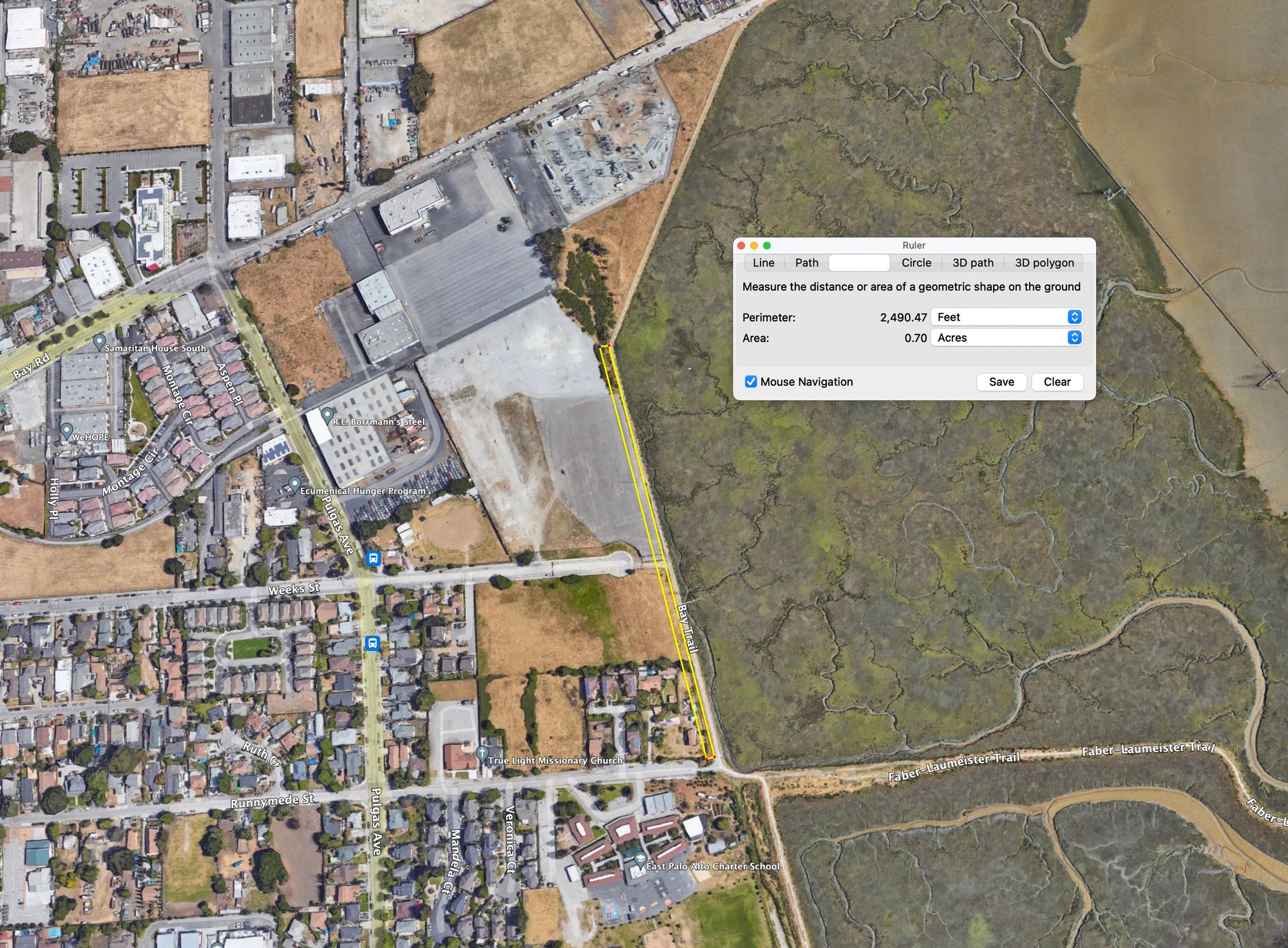
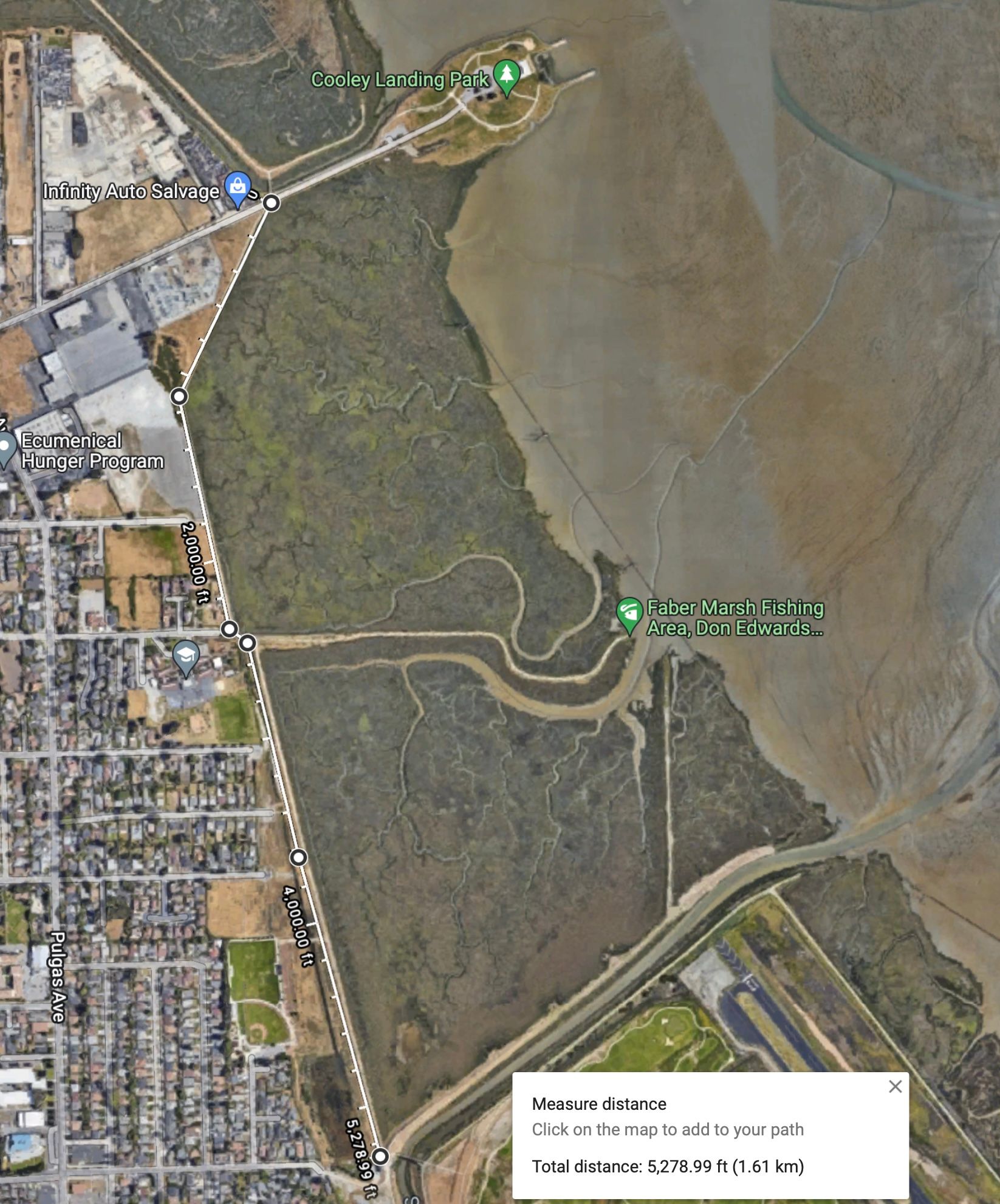
Next, I did a back-of-the-envelope calculation and estimate that around 6.06 acres of potential park land would be removed by this flatter slope ratio. I got to this by multiplying the 5,280 (1 mile) linear feet of levee length south of Bay Road and multiplying it by 50 feet, which results in 264,000 sqft, or 6.06 acres.
This is a problem that 6 acres will be taken away because there are multiple parks proposed along this stretch. There are designs for the revamped Martin Luther King, Jr. Park. Harvest Properties has also proposed multiple public parks on their The Landing project. The parks are evidenced in their Major Application to the City of East Palo Alto, which is found on their Courbanize website on the bottom of the Info page. Part of the reason why only parks are proposed on these stretches of land is that the San Francisco Bay Conservation and Development Commission (BCDC) enforces a 100 foot shoreline band: structures cannot be built within 100 feet of the shoreline.
Some people might say that we can simply ask the developers to reduce their proposed building footprints; they are making enough money and can reduce their building footprint so that the parks that they create are the same size as before. In theory, this scenario could play outand the community would get the parks, and the smaller office buildings may align with a smaller approved Ravenswood Business District general plan of 2.8 or 3.3 million square feet. I would argue against this line of thought though because if developers cannot build as large, then they can also afford to give less concessions or improvements to the community.
In conclusion, I wanted to inform the community about the Notice of Preparation. I introduced the concept of the 7:1 levee slope ratio, and I provided a back-of-the-envelope calculation of the potential future parkland that could be lost from this newly proposed gentler sloped levee. I am advocating that the San Francisquito Creek Joint Powers Authority can consider the options of extending the levee into the marsh instead of taking private land, or that they consider negotiating the levee slope to be less gradual. Also, if you would like to learn more or get involved, there are meeting this week! Here is the flyer I received.